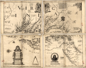
 This map was created in 1670; while not as detailed as John Smith’s map, it includes the English settlements that had started to emerge since the beginning of the English colonization. It can be considered the transitional period between when the Native tribes controlled the region and when English settlers began founding towns and farms. Like the John Smith map made earlier in the 17th century, this one also includes the Indian settlements that used to live in the region that became Arlington/Alexandria/Washington as well as the European settlements that emerged following Jamestown’s success. An example of such a settlement could have been found near Analostan (modern-day Theodore Roosevelt) Island, home of the Necostin Tribe.
The creators of this map included Augustine Herrman who was the first naturalized citizen of Maryland, and famously the creator of the first accurate map of the Chesapeake Bay area- this one. Herrman was born in Prague and first arrived in the Americas as an ambassador by the Netherlands to resolve territorial disputes between the Dutch, British and Native tribes. He returned to Europe after he finished his mission, then collected his family and moved to the Maryland Colony. The accuracy of the map is important because it shows the increasing knowledge of the European settlers, and the “taming” of the eastern coast. It highlights that while Native Americans might have still lived in the area, the land was increasingly being claimed by new European arrivals.

