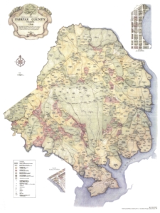
 This map, created by Beth Mitchell in 1987 for Fairfax County, shows property lines, owners, and number of slaves for each farm/property in 1760 northern Virginia. The map indicates that the majority of Fairfax County, including all of modern day Arlington, was either farmland or unclaimed. This also serves to highlight how sparsely populated the area was at the time. Note: the map does not indicate the number of Indian tribes in the region. This map represents when the English colonists ruled the area, before the Colonies won their independence when the people were proud to call themselves citizens of the British Empire. Where the previous maps did not show property lines and the land was “unclaimed”, now the majority of the land belongs to landowners, some of whom are well known, such as George Washington,John Carlyle, Lord Fairfax and his family. This map also represents the Europeanization of the region. The rural nature of the area remained relatively unchanged for over a century, until in the early 20th century Arlington’s proximity to Washington D.C. encouraged its urbanization. One of the farms listed on the map belongs to John Ball, whose original house still stands in Arlington. The house represents the legacy of the original settlers who laid the foundation for what would become Arlington, Virginia.

