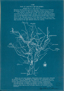
 This map was created in 1791-1793 by Andrew Elliot, a surveyor, and a mentor of Lewis who, alongside Clark, were tasked by President Jefferson to travel to the West Coast.
The map is relatively sparse on details, and does not include the farms and properties in the area. However, it does show the outline of the District of Columbia, along with several roads and waterways that could be found in the region. It also indicates the towns located in the area, alongside Mount Vernon. George Washington selected and helped survey the land that would make up the District of Columbia, which was to serve as the capital of the United States. These borders later marked Alexandria County when the Virginia side of D.C. was returned to the state.

