 https://arlhist.org/wp-content/uploads/2025/08/16-2-scaled.jpg
1800
2560
Peter Vaselopulos
/wp-content/uploads/2024/07/arlhist-logo-cm-02.png
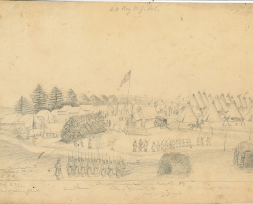
Peter Vaselopulos2025-08-22 21:24:072025-08-24 13:42:49Sketching the Civil War
https://arlhist.org/wp-content/uploads/2025/08/16-2-scaled.jpg
1800
2560
Peter Vaselopulos
/wp-content/uploads/2024/07/arlhist-logo-cm-02.png
Peter Vaselopulos2025-08-22 21:24:072025-08-24 13:42:49Sketching the Civil War https://arlhist.org/wp-content/uploads/2025/08/student-contest.jpg
984
1816
Peter Vaselopulos
/wp-content/uploads/2024/07/arlhist-logo-cm-02.png
Peter Vaselopulos2025-08-18 15:23:062025-10-17 14:10:182025 Student History Contest Winners
https://arlhist.org/wp-content/uploads/2025/08/student-contest.jpg
984
1816
Peter Vaselopulos
/wp-content/uploads/2024/07/arlhist-logo-cm-02.png
Peter Vaselopulos2025-08-18 15:23:062025-10-17 14:10:182025 Student History Contest Winners https://arlhist.org/wp-content/uploads/2024/10/Arlington-VA250-small.jpg
159
500
Peter Vaselopulos
/wp-content/uploads/2024/07/arlhist-logo-cm-02.png
Peter Vaselopulos2025-08-16 09:47:062025-08-16 10:50:06Arlington VA250 Resources
https://arlhist.org/wp-content/uploads/2024/10/Arlington-VA250-small.jpg
159
500
Peter Vaselopulos
/wp-content/uploads/2024/07/arlhist-logo-cm-02.png
Peter Vaselopulos2025-08-16 09:28:272025-08-16 10:50:37About Arlington VA250
https://arlhist.org/wp-content/uploads/2024/10/Arlington-VA250-small.jpg
159
500
Peter Vaselopulos
/wp-content/uploads/2024/07/arlhist-logo-cm-02.png
Peter Vaselopulos2025-08-16 09:47:062025-08-16 10:50:06Arlington VA250 Resources
https://arlhist.org/wp-content/uploads/2024/10/Arlington-VA250-small.jpg
159
500
Peter Vaselopulos
/wp-content/uploads/2024/07/arlhist-logo-cm-02.png
Peter Vaselopulos2025-08-16 09:28:272025-08-16 10:50:37About Arlington VA250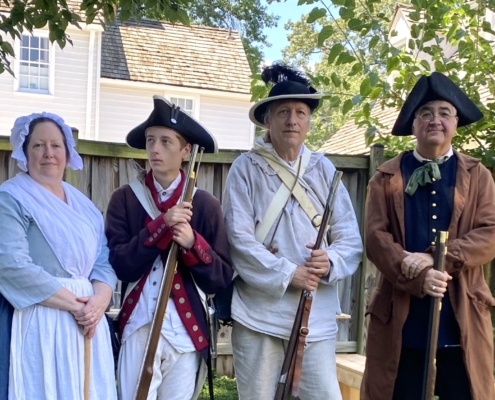 https://arlhist.org/wp-content/uploads/2025/08/IMG_5279-scaled-e1755308283665.jpeg
1156
1937
Peter Vaselopulos
/wp-content/uploads/2024/07/arlhist-logo-cm-02.png
Peter Vaselopulos2025-08-15 20:52:162025-08-16 08:35:431775 Fairfax Muster
https://arlhist.org/wp-content/uploads/2025/08/IMG_5279-scaled-e1755308283665.jpeg
1156
1937
Peter Vaselopulos
/wp-content/uploads/2024/07/arlhist-logo-cm-02.png
Peter Vaselopulos2025-08-15 20:52:162025-08-16 08:35:431775 Fairfax Muster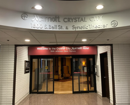 https://arlhist.org/wp-content/uploads/2025/08/crystal-city-shops-arlington-va-v0-h5repfc99iyc1.webp
810
1080
Peter Vaselopulos
/wp-content/uploads/2024/07/arlhist-logo-cm-02.png
Peter Vaselopulos2025-08-13 20:57:462025-08-13 21:00:13Mysterious Tunnels
https://arlhist.org/wp-content/uploads/2025/08/crystal-city-shops-arlington-va-v0-h5repfc99iyc1.webp
810
1080
Peter Vaselopulos
/wp-content/uploads/2024/07/arlhist-logo-cm-02.png
Peter Vaselopulos2025-08-13 20:57:462025-08-13 21:00:13Mysterious Tunnels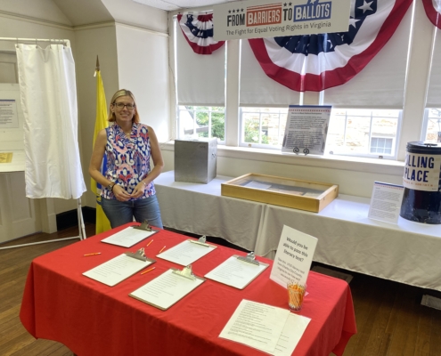 https://arlhist.org/wp-content/uploads/2025/08/IMG_5251-scaled.jpeg
1920
2560
Peter Vaselopulos
/wp-content/uploads/2024/07/arlhist-logo-cm-02.png
Peter Vaselopulos2025-08-07 11:00:472025-08-16 10:27:37From Barriers to Ballots
https://arlhist.org/wp-content/uploads/2025/08/IMG_5251-scaled.jpeg
1920
2560
Peter Vaselopulos
/wp-content/uploads/2024/07/arlhist-logo-cm-02.png
Peter Vaselopulos2025-08-07 11:00:472025-08-16 10:27:37From Barriers to Ballots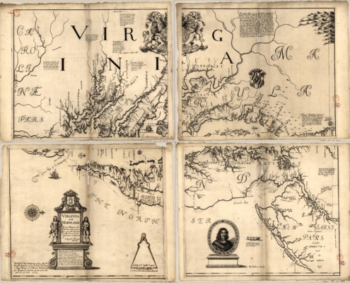 https://arlhist.org/wp-content/uploads/2025/08/1670-Map-scaled.jpg
2040
2560
Peter Vaselopulos
/wp-content/uploads/2024/07/arlhist-logo-cm-02.png
Peter Vaselopulos2025-08-04 08:26:512025-08-04 08:26:511670 Map
https://arlhist.org/wp-content/uploads/2025/08/1670-Map-scaled.jpg
2040
2560
Peter Vaselopulos
/wp-content/uploads/2024/07/arlhist-logo-cm-02.png
Peter Vaselopulos2025-08-04 08:26:512025-08-04 08:26:511670 Map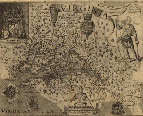 https://arlhist.org/wp-content/uploads/2025/08/Virginia-1606-Map.jpg
962
1249
Peter Vaselopulos
/wp-content/uploads/2024/07/arlhist-logo-cm-02.png
Peter Vaselopulos2025-08-04 08:19:222025-08-04 08:19:22Virginia Map-1606
https://arlhist.org/wp-content/uploads/2025/08/Virginia-1606-Map.jpg
962
1249
Peter Vaselopulos
/wp-content/uploads/2024/07/arlhist-logo-cm-02.png
Peter Vaselopulos2025-08-04 08:19:222025-08-04 08:19:22Virginia Map-1606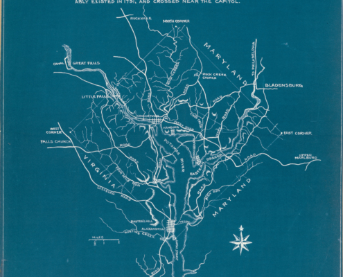 https://arlhist.org/wp-content/uploads/2025/08/1791-map-scaled.jpg
2560
1805
Peter Vaselopulos
/wp-content/uploads/2024/07/arlhist-logo-cm-02.png
Peter Vaselopulos2025-08-03 08:59:592025-08-03 08:59:591791 Map
https://arlhist.org/wp-content/uploads/2025/08/1791-map-scaled.jpg
2560
1805
Peter Vaselopulos
/wp-content/uploads/2024/07/arlhist-logo-cm-02.png
Peter Vaselopulos2025-08-03 08:59:592025-08-03 08:59:591791 Map