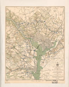
 The map was created in 1865, around the end of the Civil War. The map shows the 68 forts that surrounded Washington D.C., that were built to protect it from Confederate attack. The map also includes the City of Alexandria, several landmarks and farms that were in the area. It also identifies that the 22 forts that were built in Arlington. One of the remaining forts, C.F. Smith is identified and can still be visited. The only recorded attack on one of these forts occurred on July 12, 1864. The Battle of Fort Stevens represents the only time a sitting president (Abraham Lincoln), come under enemy fire. But the forts served another purpose, as beacons of freedom. Contraband, or former enslaved refugees, sought safety behind the protection of the forts.
For more information: