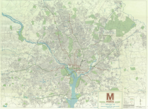
 This map was created by Metro in 1968, showcasing not only the initial rail lines that were planned, but also future extensions—including one to Dulles Airport. The map highlights a shift in how people could travel within the D.C. area, adding new transportation options alongside highways. As seen in later (chronological) maps, the Metro significantly impacted population growth, with denser centers forming around the system. This was intentional, as a major goal of the Metro was to revitalize the area to meet the rising population and demand for public transportation. The creation of the Metro not only provided better transportation options—reducing car traffic and making it easier for many to commute—but also promoted further urbanization, growth in population and business, and fostered prosperity in Arlington. Additionally, it further connected Arlington to Washington D.C. with a direct line crossing the river from one side of Arlington County to the other.

 General Land Use Plan Map 1975