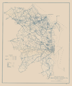
 Arlington became a separate county in 1920, splitting from Alexandria in the same way that the latter (along with what would become Arlington) split from the District of Columbia. This map of rural delivery routes was one of the first maps to include Arlington County as its own entity. Note that while there are pockets of urbanization in the north and south—near the city of Alexandria—most of the Arlington area is rural. This marks the “beginning” of Arlington as its own county, meaning that before this point, “Arlington”—as we know it today—did not exist; it was instead simply part of larger counties like Alexandria or Fairfax. This isn’t to say it lacked its own identity, but rather that its local history up to this point was closely linked with neighboring jurisdictions. The year 1920 marked a new chapter when Arlington began appearing on maps, allowing the county to grow both in identity and population.

 Urban Growth Map