A photo of the early turnpike
Early Pathways
Long before Columbia Pike was paved for automobiles, the land was crossed by trails made by large game and later used by Native peoples. These routes followed the high ground, giving travelers a wide view of the landscape and a measure of safety. Local historians Judith Knudsen Collins and Eleanor Lee Templeman Stewart wrote in a 1989 issue of the Arlington Historical Magazine that these paths formed the earliest foundations of what would become one of Arlington’s most important roads.
The modern turnpike was chartered in 1808, when Congress authorized the Columbia Turnpike Company to build a road from Washington’s Long Bridge to the Little River Turnpike in Fairfax. Because the area was then part of the District of Columbia, Congress oversaw its creation, while Virginia set up a separate company to carry the road beyond the district line. At toll gates along the way, travelers paid fees before a heavy wooden “pike” was turned aside to let them pass, the historians noted.
Farms, Families, and Faith
For much of the early 19th century, Columbia Pike wound its way through farmland and scattered homesteads. Among the landowners were George Washington Parke Custis of Arlington House and families such as the Hunters, Munsons, Jenks, Corbetts, and Youngs. Churches soon followed. Trinity Church grew out of Custis’s private chapel, while Hunter’s Chapel, founded in the 1850s, became a center of community life until both were destroyed during the Civil War.
Civil War Transformations
With the outbreak of the Civil War, Columbia Pike became a vital artery in the defenses of Washington. Federal troops fortified the road with strongpoints including Fort Runyon, Fort Albany, Fort Richardson, and Fort Berry, all guarding approaches to the capital. Local residents were displaced, farms destroyed, and churches dismantled for military use.
In 1863, the federal government established Freedman’s Village on land adjacent to the Pike. This community provided housing, education, and jobs for formerly enslaved people and their families. Though the village closed in the 1890s, many residents settled in Arlington neighborhoods such as Nauck, today called Green Valley, and Arlington View, establishing enduring communities.
Streetcars and Suburbs
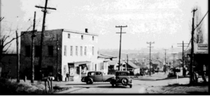
With peace came growth. In the early 20th century, an electric trolley linked Rosslyn to Nauck, with a busy stop at Columbia Pike and Walter Reed Drive. By the 1920s, cafes, drugstores, and shops clustered there, and buildings from the 1920s and 30s created a walkable corridor. Arlington County’s planning history notes that the Pike mirrored the character of other transit hubs in the region during this era.
Automobiles and Commercial Strips
The automobile brought sweeping changes. Shopping centers like Arlington Village and Westmont opened in the 1930s and 40s, promoting the new “one-stop” shopping model. Gas stations, dealerships, and service garages lined the Pike. After World War II, the road was widened to four lanes, on-street parking was eliminated, and new office complexes and drive-through restaurants gave the corridor an auto-oriented identity.
Revitalization Efforts
By the late 20th century, congestion and disinvestment weighed heavily on Columbia Pike. In response, Arlington adopted the Columbia Pike Revitalization Plan in 1990, followed by the Columbia Pike Initiative in 1998 and a Form-Based Code in 2003. Arlington County and the Arlington Historical Society note that these measures aimed to restore the Pike’s “Main Street” character while balancing growth, transit, and affordable housing.

