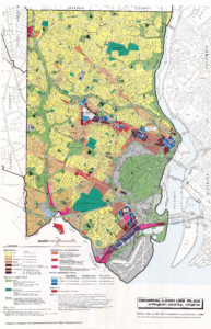
 Commissioned by the Arlington County Department of Community Affairs in 1983, this map closely resembles the 1975 map but highlights key differences, such as population growth and shifts in the business landscape. Notice the increase in apartments since 1975, and observe that major population centers, along with apartments and businesses, are concentrated in the north around the Metro. In the south, apartments and commercial areas are located near the airport by comparison. Overall, the map indicates a steady population growth through the late 20th century. It also shows—because of the focus around the Metro lines—that the railway has a direct impact on Arlington County. This influence extends beyond just population and growth, as noted in the 1960s map, affecting the county’s structure, where people live, where businesses develop, and how residents travel. Arlington’s history has always been one of growth, from early settlers claiming more land to the Army expanding fortifications during the Civil War. The population has expanded alongside changes in the area, from the mass immigration of escaped slaves to refugees fleeing South Vietnam. Much of this growth revolves around Wilson Boulevard, in the same way that the Metro—built beneath that street—helps drive contemporary expansion. Arlington’s development is driven by the ability to travel; people moving in and out easily. It was the proximity to Washington D.C.—while remaining outside the District—that made Arlington so attractive from the start. Even if the era of drastic change has ended—no more farms to develop—Arlington continues to evolve, evident in the expansion of various businesses and apartments shown on the map.

 Civic Associations Map 2024