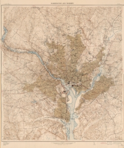
 Similar to the 1932 map, the 1944 map was created by the U.S. Department of the Interior and shows the transition of Arlington from a rural community to a more urbanized center. This map also depicts the creation of the Pentagon, both a major landmark and a source of jobs. It should be noted that construction displaced an African American community called Queen City that lived in the area. The Pentagon was built in Arlington due to a lack of space in Washington, D.C., and the need for a dedicated military headquarters. This marks an “expansion” of Federal offices into Arlington, with several departments headquartered in the county—one of the most prominent being the Pentagon. It also reflects the relationship Arlington has with the nation’s capital. Many Arlington residents are Federal workers who commute into D.C., either by car or Metro—one of the main reasons why the rail system encouraged population growth and settlement near its stations. Despite being separate entities for more than a century, D.C. and Arlington remain closely connected, meaning that any impact on one generally affects the other, and decisions made by the Federal Government directly influence Arlington’s growth and economy.

 Metro Map 1968