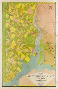
 This map was created in 1900, when Arlington was still part of Alexandria County. It shows how Arlington’s rural character persisted into the 20th century and highlights that, for most of its history, it was not a single community but a collection of farms and small towns. There were several clusters of urban development, such as the city of Alexandria—the largest at the time. Several farms and communities visible on the map, like Rosslyn’s Farm, Arlington Heights, and Penrose, have given their names to modern neighborhoods. This underscores the lasting legacy of that era into today. The map was commissioned by the Virginia Title Company, which ensures property claims in Virginia are legitimate, and was created by Howell and Taylor, two civil and topographical engineers.

 Arlington 1920