
![]() This online exhibition is part of the VA250 Commemoration. For over 400 years, maps have documented Arlington County’s rich history, which predates the arrival of Europeans in Virginia and is marked by ongoing change and growth. After the revolution and independence, the area along the Potomac River was designated as the District of Columbia in 1801, with Arlington—then known as Alexandria County—being incorporated into D.C. on the Virginia side. In 1847, Alexandria County retroceded back to Virginia. During the Civil War, the U.S. Army defended the area against a Confederate attack on Washington, D.C. Following the war, Arlington gradually transitioned from rural farmland to an urban area. Diversity has always played a role in shaping Arlington, from freed enslaved persons, establishing African American communities, to the Vietnamese enclave in Clarendon in the 1970s. Advances in public transit, especially the Metro, spurred further development and investment, attracting more residents. Arlington’s story reflects a history of continual change, growth, and development. The following maps have been selected because of the unique stories they tell about Arlington’s history.
This online exhibition is part of the VA250 Commemoration. For over 400 years, maps have documented Arlington County’s rich history, which predates the arrival of Europeans in Virginia and is marked by ongoing change and growth. After the revolution and independence, the area along the Potomac River was designated as the District of Columbia in 1801, with Arlington—then known as Alexandria County—being incorporated into D.C. on the Virginia side. In 1847, Alexandria County retroceded back to Virginia. During the Civil War, the U.S. Army defended the area against a Confederate attack on Washington, D.C. Following the war, Arlington gradually transitioned from rural farmland to an urban area. Diversity has always played a role in shaping Arlington, from freed enslaved persons, establishing African American communities, to the Vietnamese enclave in Clarendon in the 1970s. Advances in public transit, especially the Metro, spurred further development and investment, attracting more residents. Arlington’s story reflects a history of continual change, growth, and development. The following maps have been selected because of the unique stories they tell about Arlington’s history.
 https://arlhist.org/wp-content/uploads/2025/07/Arlington-1920.webp
1600
1341
Peter Vaselopulos
/wp-content/uploads/2024/07/arlhist-logo-cm-02.png
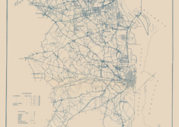
Peter Vaselopulos2025-07-09 19:12:472025-07-10 08:29:57Arlington 1920
https://arlhist.org/wp-content/uploads/2025/07/Arlington-1920.webp
1600
1341
Peter Vaselopulos
/wp-content/uploads/2024/07/arlhist-logo-cm-02.png
Peter Vaselopulos2025-07-09 19:12:472025-07-10 08:29:57Arlington 1920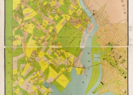 https://arlhist.org/wp-content/uploads/2025/07/Virginia-Title-Map-scaled.jpg
2560
1686
Peter Vaselopulos
/wp-content/uploads/2024/07/arlhist-logo-cm-02.png
Peter Vaselopulos2025-07-09 18:59:402025-07-16 21:08:14Map of Alexandria County
https://arlhist.org/wp-content/uploads/2025/07/Virginia-Title-Map-scaled.jpg
2560
1686
Peter Vaselopulos
/wp-content/uploads/2024/07/arlhist-logo-cm-02.png
Peter Vaselopulos2025-07-09 18:59:402025-07-16 21:08:14Map of Alexandria County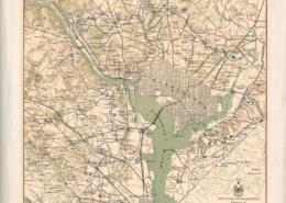 https://arlhist.org/wp-content/uploads/2025/07/Defenses-of-Washington-scaled.jpg
2560
2021
Peter Vaselopulos
/wp-content/uploads/2024/07/arlhist-logo-cm-02.png
Peter Vaselopulos2025-07-09 16:54:042025-07-10 08:19:26Civil War Defenses of Washington 1865
https://arlhist.org/wp-content/uploads/2025/07/Defenses-of-Washington-scaled.jpg
2560
2021
Peter Vaselopulos
/wp-content/uploads/2024/07/arlhist-logo-cm-02.png
Peter Vaselopulos2025-07-09 16:54:042025-07-10 08:19:26Civil War Defenses of Washington 1865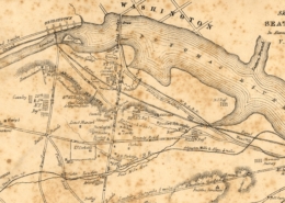 https://arlhist.org/wp-content/uploads/2025/04/Corbett-Map-scaled.jpg
1311
2560
Peter Vaselopulos
/wp-content/uploads/2024/07/arlhist-logo-cm-02.png
Peter Vaselopulos2025-07-08 22:59:122025-07-11 14:30:18Seat of War Map
https://arlhist.org/wp-content/uploads/2025/04/Corbett-Map-scaled.jpg
1311
2560
Peter Vaselopulos
/wp-content/uploads/2024/07/arlhist-logo-cm-02.png
Peter Vaselopulos2025-07-08 22:59:122025-07-11 14:30:18Seat of War Map