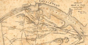
 On the early morning of May 24, 1861, thousands of Federal troops crossed the Potomac River to establish defensive positions in what is today Arlington County. These troops, coming from all over the North, set up dozens of camps, started work on building forts, and disrupted the peaceful life of those living there. Because of Virginia’s neutrality during the early phases of the secession crisis, Federal leadership had avoided sending cartographers into Arlington and Alexandria so as not to give the appearance of a pretext to war and invasion. Virgil P. Corbett (1827–1875), a local farmer, lawyer, politician, inventor, and businessman who called Arlington home, saw an opportunity to create a map for the government. Corbett, although likely lacking formal training in cartography, quickly set out to create a map. Over the course of a week between May 24th and 31st, Corbett travelled across Arlington, Alexandria, and parts of Fairfax. He sketched roads, topographic features, towns, farms, fortifications, as well as the disposition of Federal regiments and artillery batteries scattered across the region, including which states they were from and occasionally who their commanders were. It is likely that by the end of his endeavor, Corbett knew more about the positions of Federal troops than most members of the military high command. On May 31st, he finished his first foray into map-making, titling it A Sketch of the Seat of War in Alexandria & Fairfax Counties.
For more information: