The Triumphs and Tribulations of Virgil P. Corbett: Arlington’s Civil War Cartographer
By: Aidan “Mitch” Shakespeare
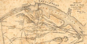 Virgil P. Corbett (1827 – 1875) was a farmer, lawyer, politician, inventor, and businessman who called Arlington his home during the years before and after the Civil War. Originally from New York, Corbett is perhaps best known for creating some of the first maps of what we now call Arlington County and its surrounding areas during the Civil War, including Sketch of the Seat of War in Alexandria & Fairfax Counties (1861) and his Map of the Seat of War Showing the Battles of July 18th and 21st, 1861 (1861).
Born into a prosperous family in the hamlet of Corbettsville, New York, Corbett was able to obtain a high-level education which left him adept in matters of the law, business, engineering, and drawing. In the early 1850s, Corbett worked as an attorney in New York City while he tinkered and invented products on the side, a hobby which would last until the end of his life. Throughout his life, he would receive patents for improvements in the usage of rubber in the construction of ships, ventilation and air filtration devices for railroad cars, improvements in the canning of food, and the creation of a “potato-digger,” amongst many other inventions.1
He would move to the area now known as Arlington in April 1858, following in the footsteps of his father, Cooper, and his brothers Frank and Sewell, who had purchased land in Arlington throughout the late 1840s and early 1850s. Corbett purchased a 98-acre farm just south of Ball’s Cross Roads (known today as Ballston), near where modern Route 50 crosses over Glebe Road. His brother Sewell owned a farm near where the Columbia Turnpike crosses over Doctor’s Branch, and Cooper owned land near the modern intersection of South Glebe Road and South Walter Reed Drive. Corbett would be in Arlington when in the wee hours of May 24th, 1861, Union troops crossed over the Potomac and occupied Arlington because of Virginia’s secession from the Union.2
At the outbreak of the war, and even as the Union Army had soldiers actively marching into hostile territory, they were lacking one piece of mission-critical equipment: accurate maps. Because of Virginia’s neutrality during the early phases of the secession crisis, Union leadership had avoided sending cartographers into Arlington and Alexandria so as not to give the appearance of a pretext to war and invasion. John G. Barnard, a colonel in the U.S. Army Corps of Engineers and “father” of the defenses of Washington, recalled in a report after the war:
Officers of the Army who had spent much of their lives in Washington or New York found themselves more ignorant concerning the military features of the surrounding country than they were of Paris, to which military history and its fortifications had attracted some attention.
Corbett, although likely lacking any formal training on the methods of cartography, quickly set out to resolve the Union’s problem for the purpose of patriotism and profit.3
Over the course of a week between May 24th and 31st, Corbett travelled across Arlington, Alexandria, and parts of Fairfax. He tirelessly sketched roads, topographic features, towns, farms, fortifications, as well as the disposition of Union regiments and artillery batteries scattered across the region, including which states they were from and occasionally who their commanders were. It is likely that by the end of his endeavor, Corbett knew more about the positions of Union troops than most members of the Union military high command. On May 31st he finished his first foray into map making, titling it A Sketch of the Seat of War in Alexandria & Fairfax Counties.4
Corbett’s finished map was both simultaneously underwhelming yet significant. It was underwhelming in the sense of actual cartographic value; it lived up to its name as a “sketch” and its scale was inaccurate and a bit deceptive. Moreover, it quickly became outdated as more troops passed into the area and fortifications were expanded and given names. For this reason, very few copies of his original map were ever printed or distributed. But this map was also a significant achievement of dedication and innovativeness, and although it did not enjoy much success, there are reports that the map made it onto the desk of then-commander of Union forces Irvin McDowell. With a foothold in the realm of cartography and a curb in the market, Corbett dedicated himself once more to the creation of a new map, which would be bigger, more marketable, and more ambitious than the last.5
Over the next few months, Corbett spent his time sketching, gathering intelligence, and traveling about the area, working closely with a professional draughtsman named E. R. McKean to create a more polished, less-sketch-like map. During the lead up and battle of First Bull Run (July 21st, 1861), it seems likely that Corbett embedded himself alongside Union troops and civilian spectators, as he recorded fairly accurate troop positions during the battle that would become the first major defeat for the Union Army. By late August, Corbett published his second map titled Map of the Seat of War Showing the Battles of July 18th and 21st 1861 and began overseeing efforts for its widespread sale and printing. While newspapers advertised his new map, Corbett wandered through the streets of Washington and sold copies to interested buyers, charging twenty-five cents apiece, or approximately $10 a map adjusted for inflation. His laissez-faire approach to using military intelligence as a business model, however, would soon have unintended consequences.6
In the meantime, however, Corbett enjoyed substantial success in the business of cartography, leading him to once again partner with McKean to create yet another, even larger map than his first and second. Likely feeling he was on a winning streak; Corbett grew bolder and more flagrant in his attempts to obtain information. In one case, his boldness nearly led to his death or capture by Confederate forces. One September 16th, 1861, The New York Times reported:
Mr. V. P. CORBETT, of this city, made a reconnaissance near Munson’s Hill. He went so close to the rebel works that he was discovered and chased by the rebels. In order to effect his escape, he was obliged to abandon his horse and take to a piece of thick woods, into which the rebel cavalry could not penetrate.
This record also shows that Corbett’s name was beginning to reverberate throughout the Union as an expert of military matters within the Northern Virginia region. By late October or early November, Corbett published his third map titled Map of the Seat of War Showing the Battles of July 18th, 21st & Oct. 21st, 1861, this time showing yet another crushing Union defeat at Ball’s Bluff near Leesburg, Virginia.7
But Corbett’s growing influence and posterity had the unintended effect of making him a target for accusations of espionage and treason. The beginning of his problems arose when he filed a complaint on behalf of his father, Cooper, to Secretary of State William H. Seward. In a letter dated November 19th, Corbett alleged that a man named James B. Leach was illegally harvesting timber on Cooper’s property, selling the cut timber to “wood dealers” for personal profit. Leach, a contractor under the employment of the Union Army, oversaw the delivery of cord wood for military usage. Virgil pleaded to Seward, “If government requires [the wood] to be cut as a ‘military necessity,’ I interpose no objection, but I do most earnestly protest against this unlawful depredation and respectfully ask redress from your hands.” Corbett’s complaint was backed by an enclosed letter by Brigadier General William R. Montgomery, the military governor of Alexandria, who confirmed that Leach was operating illegally and recommended criminal prosecution for the contractor.8
When word of Corbett’s complaint reached Leach in mid-December, it clearly struck a nerve. The contractor immediately accused Corbett of treason and had him arrested, sending him into the custody of Provost Marshall Andrew Porter. Word of Corbett’s arrest spread like wildfire, and rumors of his alleged treason made it into the newspapers. One Washington paper claimed Corbett had been arrested “in General McCall’s camp as a spy,” and “he is charged with having gone beyond our lines and communicated with the enemy.” A correction to this statement was posted a few weeks later which refuted this rumor.9
To his end, Leach issued a statement where he defended his arrest of Corbett. Leach claimed an informant, “… Says he is well acquainted with Mr. Corbett [and] has known him for 3 months, and thinks he is a disloyal man, and [the] informant believes he gives all the information he can to the enemy.” Leach never reveals who his “informant” was during his statement, but continues:
Major Schutte, Division Quarter Master, Blenkers Div, told this informant that he had seen a Richmond Paper, (don’t know the date) but it is now on file in Genl McClellan’s office, in this paper there was a “map” published showing the country all around “Roachs Mill” “to Hunters Chapel” giving the locations of the different camps [and] the names of all the farms excepting Corbett’s Farm [sic].
It should be noted that each version of Corbett’s Seat of War maps contained the location of his or his family’s farms, and a copy of the “Richmond Paper” containing the alleged map remains elusive.10
Corbett’s imprisonment did not last long, however, as Frederick W. Seward, son of William H. Seward and the Assistant Secretary of State, ordered Provost Marshal Porter to release Virgil from custody on December 19th. Seward wrote, “Set Mr. V. P. Corbett as released on giving his parole of honor to surrender himself into your custody whenever required to do so by this Department.” Corbett’s parole forced him to remain in the area until he was formally charged and stood trial, but it does not appear that a formal charge ever occurred. Leach’s testimony, it seems, did not convince military or civil authorities to prosecute Corbett for treason. Corbett’s political affiliation and connections likely contributed to this as well.11
The great irony of Corbett’s ordeal was that he was about as far from a traitor as one could get at that time; Corbett was a Republican, and he had outwardly advertised himself as a “Lincoln man” throughout the 1860 presidential election. He detested the idea of secession. Moreover, his work as an attorney in New York City and Washington had granted him political connections amongst the Republicans in the House of Representatives. So strong were these connections that in July 1861, 37 moderate and abolitionist House Republicans recommended Corbett for the position of “Doorkeeper of the Senate (more often referred to as the Senate Sergeant-at-Arms).” In the case of Corbett, it seems more likely that his foray into cartography had more to do with personal profit than it did an act of treason.12
Corbett’s arrest deeply affected him, as he never again ventured into the business of map making. Indeed, he eventually left Arlington altogether and moved back to New York City until the end of the war. That is not to say that he entirely removed himself from his interests and properties in Arlington; throughout 1864, Corbett was in contact with military authorities in Washington to try to purchase land abandoned by Confederate sympathizers within Arlington County.13
When the war ended in 1865, Corbett moved back to Arlington and resumed his life as a farmer, attorney, and inventor. He additionally was elected twice as the treasurer for Alexandria County until his eventual death on May 25th, 1875, near exactly fourteen years apart from when his first map was published. He was 48 years old. Though largely forgotten today, Corbett’s brief but impactful career as a wartime cartographer remains a fascinating footnote in the history of Arlington and the Civil War
Works Cited:
1 Smith, Henry P. History of Broome County: With Illustrations and Biographical Sketches of Some of Its Prominent Men and Pioneers. Syracuse: Mason & company, 1885, pgs. 478-483.
Livingston, John. Livingston’s Law Register: Containing a List of Lawyers in the United States, Designating Who Are in Practice, Retired on the Bench, and All Law-Firms, with the Individual Partners. New York City, 1856, p. 203.
Corbett, Virgil P. Improvement in the Construction of Ships and Navigable Vessels. United States Patent Office US12359A. Corbettsville, New York, issued February 6, 1855.
Corbett, Virgil P. Improvement in Car-Ventilation. United States Patent Office US12541A. Corbettsville, New York, issued March 20, 1855.
Corbett, Virgil P. Improvement in Ventilators for Railroad-Cars. United States Patent Office US13779A. New York City, New York, issued November 13, 1855.
Corbett, Virgil P. Improvement in Stoppers for Preserve-Cans. United States Patent Office US25490A. Washington, DC, issued September 20, 1859.
Corbett, Virgil P. Improvement in Potato Digger. United States Patent Office US83833A. Alexandria, Virginia, issued November 10, 1868.
2 Goode, James M. The Evolution of Washington, DC: Historical Selections from the Albert H. Small Washingtonia Collection at the George Washington University. Washington, DC: Smithsonian. 2015, p 88.
Corbett, Gordon L. Thirteen Generations of Descendants of Robert Corbett Who Died September 18, 1695, in Woodstock, Connecticut. 1995, p. 30.
3 Barnard, John G. A Report on the Defenses of Washington, to the Chief of Engineers, by Brevet Major General J. G. Barnard, Colonel, Corps of Engineers, U.S. Army. Washington, DC: Government Printing Office, 1871, p. 8.
4 Corbett, Virgil P. “Sketch of the Seat of War in Alexandria & Fairfax Cos.” Washington, DC, May 31, 1861.
5 Goode, The Evolution of Washington, DC, p. 88.
New York Daily Tribune. “The Rebel Outposts near Washington.” September 13, 1861. Library of Congress.
6 Corbett, Virgil P., and E. R. McKean. “Map of the Seat of War Showing the Battles of July 18th & 21st 1861.” Washington, DC, 1861.
Evening Star. August 26, 1861. Library of Congress.
Corbett, Thirteen Generations, p. 30.
7 New York Times. “How Mr. Corbett Reconnoitered at Munson’s Hill.” September 17, 1861.
Corbett, Virgil P., and E. R. McKean. “Map of the Seat of War Showing the Battles of July 18th, 21st, & Oct. 21st, 1861.” Washington, DC, 1861.
8 “Letter from Virgil P. Corbett to William H. Seward,” November 18, 1861. Corbett, V P – State: Washington – Year: 1861; Papers Relating to Citizens; War Department Collection of Confederate Records, Record Group 109. National Archives Building, Washington, D.C.
“Letter from Brig. Gen. William R. Montgomery to William H. Seward,” November 9, 1861. Corbett, V P – State: Washington – Year: 1861; Papers Relating to Citizens; War Department Collection of Confederate Records, Record Group 109. National Archives Building, Washington, D.C.
9 Evening Star. “Alleged Spy Arrested.” December 24, 1861. Library of Congress.
Evening Star. “Affairs Over the River.” January 2, 1862. Library of Congress.
10 “Statement of James B. Leach,” December 20, 1861. Corbett, Virgil P – State: Washington – Year: 1861; Papers Relating to Citizens; War Department Collection of Confederate Records, Record Group 109. National Archives Building, Washington, D.C.
11 “Letter from Frederick H. Seward to Brig. Gen. Andrew Porter,” December 19, 1861. Corbett, V P – State: Washington – Year: 1861; Papers Relating to Citizens; War Department Collection of Confederate Records, Record Group 109. National Archives Building, Washington, D.C.
12 Evening Star. “Affairs Over the River.” January 2, 1862.
“Letter from Members of the House of Representatives,” June 2, 1861. Corbett, V P – State: Washington – Year: 1861; Papers Relating to Citizens; War Department Collection of Confederate Records, Record Group 109. National Archives Building, Washington, D.C.
13 “Letter from Virgil P. Corbett to Maj. Gen. A. A. Augur,” September 21, 1864. Corbett, V P – State: Washington – Year: 1861; Papers Relating to Citizens; War Department Collection of Confederate Records, Record Group 109. National Archives Building, Washington, D.C.

