
![]() This online exhibition is part of the VA250 Commemoration. For over 400 years, maps have documented Arlington County’s rich history, which predates the arrival of Europeans in Virginia and is marked by ongoing change and growth. After the revolution and independence, the area along the Potomac River was designated as the District of Columbia in 1801, with Arlington—then known as Alexandria County—being incorporated into D.C. on the Virginia side. In 1847, Alexandria County retroceded back to Virginia. During the Civil War, the U.S. Army defended the area against a Confederate attack on Washington, D.C. Following the war, Arlington gradually transitioned from rural farmland to an urban area. Diversity has always played a role in shaping Arlington, from freed enslaved persons, establishing African American communities, to the Vietnamese enclave in Clarendon in the 1970s. Advances in public transit, especially the Metro, spurred further development and investment, attracting more residents. Arlington’s story reflects a history of continual change, growth, and development. The following maps have been selected because of the unique stories they tell about Arlington’s history.
This online exhibition is part of the VA250 Commemoration. For over 400 years, maps have documented Arlington County’s rich history, which predates the arrival of Europeans in Virginia and is marked by ongoing change and growth. After the revolution and independence, the area along the Potomac River was designated as the District of Columbia in 1801, with Arlington—then known as Alexandria County—being incorporated into D.C. on the Virginia side. In 1847, Alexandria County retroceded back to Virginia. During the Civil War, the U.S. Army defended the area against a Confederate attack on Washington, D.C. Following the war, Arlington gradually transitioned from rural farmland to an urban area. Diversity has always played a role in shaping Arlington, from freed enslaved persons, establishing African American communities, to the Vietnamese enclave in Clarendon in the 1970s. Advances in public transit, especially the Metro, spurred further development and investment, attracting more residents. Arlington’s story reflects a history of continual change, growth, and development. The following maps have been selected because of the unique stories they tell about Arlington’s history.
 https://arlhist.org/wp-content/uploads/2025/08/1670-Map-scaled.jpg
2040
2560
Peter Vaselopulos
/wp-content/uploads/2024/07/arlhist-logo-cm-02.png
Peter Vaselopulos2025-08-04 08:26:512025-08-04 08:26:511670 Map
https://arlhist.org/wp-content/uploads/2025/08/1670-Map-scaled.jpg
2040
2560
Peter Vaselopulos
/wp-content/uploads/2024/07/arlhist-logo-cm-02.png
Peter Vaselopulos2025-08-04 08:26:512025-08-04 08:26:511670 Map https://arlhist.org/wp-content/uploads/2025/08/Virginia-1606-Map.jpg
962
1249
Peter Vaselopulos
/wp-content/uploads/2024/07/arlhist-logo-cm-02.png
Peter Vaselopulos2025-08-04 08:19:222025-08-04 08:19:22Virginia Map-1606
https://arlhist.org/wp-content/uploads/2025/08/Virginia-1606-Map.jpg
962
1249
Peter Vaselopulos
/wp-content/uploads/2024/07/arlhist-logo-cm-02.png
Peter Vaselopulos2025-08-04 08:19:222025-08-04 08:19:22Virginia Map-1606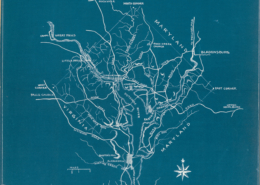 https://arlhist.org/wp-content/uploads/2025/08/1791-map-scaled.jpg
2560
1805
Peter Vaselopulos
/wp-content/uploads/2024/07/arlhist-logo-cm-02.png
Peter Vaselopulos2025-08-03 08:59:592025-08-03 08:59:591791 Map
https://arlhist.org/wp-content/uploads/2025/08/1791-map-scaled.jpg
2560
1805
Peter Vaselopulos
/wp-content/uploads/2024/07/arlhist-logo-cm-02.png
Peter Vaselopulos2025-08-03 08:59:592025-08-03 08:59:591791 Map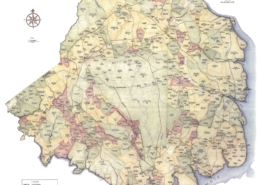 https://arlhist.org/wp-content/uploads/2025/08/fairfax1760.jpg
2304
1728
Peter Vaselopulos
/wp-content/uploads/2024/07/arlhist-logo-cm-02.png
Peter Vaselopulos2025-08-03 08:48:062025-08-03 08:48:061760 Map
https://arlhist.org/wp-content/uploads/2025/08/fairfax1760.jpg
2304
1728
Peter Vaselopulos
/wp-content/uploads/2024/07/arlhist-logo-cm-02.png
Peter Vaselopulos2025-08-03 08:48:062025-08-03 08:48:061760 Map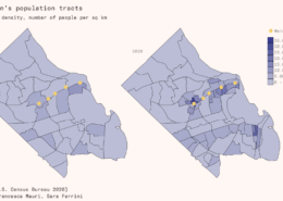 https://arlhist.org/wp-content/uploads/2025/07/02-Arlington-population-tracts-1-2048x1152-1.png
1152
2048
Peter Vaselopulos
/wp-content/uploads/2024/07/arlhist-logo-cm-02.png
Peter Vaselopulos2025-07-09 22:17:282025-07-10 07:39:18Population Growth Map 2020
https://arlhist.org/wp-content/uploads/2025/07/02-Arlington-population-tracts-1-2048x1152-1.png
1152
2048
Peter Vaselopulos
/wp-content/uploads/2024/07/arlhist-logo-cm-02.png
Peter Vaselopulos2025-07-09 22:17:282025-07-10 07:39:18Population Growth Map 2020 https://arlhist.org/wp-content/uploads/2025/07/11430_arlingtoncountylogo_color_vertical.png
384
480
Peter Vaselopulos
/wp-content/uploads/2024/07/arlhist-logo-cm-02.png
Peter Vaselopulos2025-07-09 22:05:542025-07-10 08:01:34Arlington County Map Logo 2021
https://arlhist.org/wp-content/uploads/2025/07/11430_arlingtoncountylogo_color_vertical.png
384
480
Peter Vaselopulos
/wp-content/uploads/2024/07/arlhist-logo-cm-02.png
Peter Vaselopulos2025-07-09 22:05:542025-07-10 08:01:34Arlington County Map Logo 2021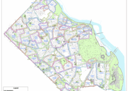 https://arlhist.org/wp-content/uploads/2025/07/Civic-Associations-MAP.png
1378
1384
Peter Vaselopulos
/wp-content/uploads/2024/07/arlhist-logo-cm-02.png
Peter Vaselopulos2025-07-09 21:53:352025-07-11 14:24:01Civic Associations Map 2024
https://arlhist.org/wp-content/uploads/2025/07/Civic-Associations-MAP.png
1378
1384
Peter Vaselopulos
/wp-content/uploads/2024/07/arlhist-logo-cm-02.png
Peter Vaselopulos2025-07-09 21:53:352025-07-11 14:24:01Civic Associations Map 2024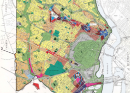 https://arlhist.org/wp-content/uploads/2025/07/1983-GLUP-scaled.jpg
2560
1644
Peter Vaselopulos
/wp-content/uploads/2024/07/arlhist-logo-cm-02.png
Peter Vaselopulos2025-07-09 21:35:072025-07-10 07:59:46Department of Community Affairs 1983 Map
https://arlhist.org/wp-content/uploads/2025/07/1983-GLUP-scaled.jpg
2560
1644
Peter Vaselopulos
/wp-content/uploads/2024/07/arlhist-logo-cm-02.png
Peter Vaselopulos2025-07-09 21:35:072025-07-10 07:59:46Department of Community Affairs 1983 Map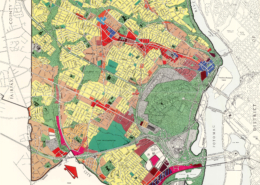 https://arlhist.org/wp-content/uploads/2025/07/1975-GLUP-scaled.jpg
2560
1645
Peter Vaselopulos
/wp-content/uploads/2024/07/arlhist-logo-cm-02.png
Peter Vaselopulos2025-07-09 21:22:362025-07-11 13:44:46General Land Use Plan Map 1975
https://arlhist.org/wp-content/uploads/2025/07/1975-GLUP-scaled.jpg
2560
1645
Peter Vaselopulos
/wp-content/uploads/2024/07/arlhist-logo-cm-02.png
Peter Vaselopulos2025-07-09 21:22:362025-07-11 13:44:46General Land Use Plan Map 1975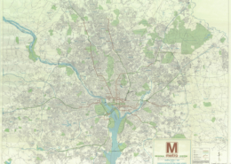 https://arlhist.org/wp-content/uploads/2025/07/Metro-Map-1968.jpg
946
1280
Peter Vaselopulos
/wp-content/uploads/2024/07/arlhist-logo-cm-02.png
Peter Vaselopulos2025-07-09 21:12:162025-07-10 08:05:58Metro Map 1968
https://arlhist.org/wp-content/uploads/2025/07/Metro-Map-1968.jpg
946
1280
Peter Vaselopulos
/wp-content/uploads/2024/07/arlhist-logo-cm-02.png
Peter Vaselopulos2025-07-09 21:12:162025-07-10 08:05:58Metro Map 1968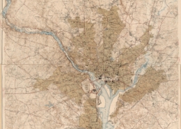 https://arlhist.org/wp-content/uploads/2025/07/Arlington-1947-scaled.jpg
2560
2141
Peter Vaselopulos
/wp-content/uploads/2024/07/arlhist-logo-cm-02.png
Peter Vaselopulos2025-07-09 20:16:562025-07-11 14:28:37Department of Interior 1944 Map
https://arlhist.org/wp-content/uploads/2025/07/Arlington-1947-scaled.jpg
2560
2141
Peter Vaselopulos
/wp-content/uploads/2024/07/arlhist-logo-cm-02.png
Peter Vaselopulos2025-07-09 20:16:562025-07-11 14:28:37Department of Interior 1944 Map https://arlhist.org/wp-content/uploads/2025/07/Arlington-1932-scaled.jpg
2560
2234
Peter Vaselopulos
/wp-content/uploads/2024/07/arlhist-logo-cm-02.png
Peter Vaselopulos2025-07-09 19:56:382025-07-11 14:26:44Urban Growth Map
https://arlhist.org/wp-content/uploads/2025/07/Arlington-1932-scaled.jpg
2560
2234
Peter Vaselopulos
/wp-content/uploads/2024/07/arlhist-logo-cm-02.png
Peter Vaselopulos2025-07-09 19:56:382025-07-11 14:26:44Urban Growth Map