 On this day in Arlington history, December 1, 1843 The Alexandria Canal, which connected the Alexandria seaport to what is now the Chesapeake & Ohio Canal National Historical Park, opened to traffic and linked to the Potomac River.
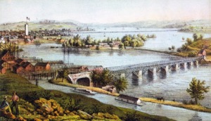
The canal ran along the route now taken by Washington Metro’s Blue Line. The canal, which ultimately ran south for seven miles through Alexandria and Virginia’s present-day Arlington County connected those areas with the community of Georgetown via the Potomac Aqueduct Bridge, played an important role in that region’s commercial development over the next few decades. Alexandria was then a part of the District of Columbia, but would be returned to Virginia about two years later in 1847. African Americans, free and enslaved, helped construct the canal, several worked for the canal company in various capacities and a few even captained their own canal boats.
The commodities shipped along that waterway to Alexandria included coal, wheat, corn, whiskey, corn meal, and flour; the various products transported from that community’s wharves via the canal included fish, salt, plaster, and lumber. The canal remained in use until 1886.
The canal route has since served as a pivotal transportation link in other key respects. A decade after the waterway closed, for example, an electric trolley line was constructed and ran along the bed of the towpath on the canal’s west side (the current location of South Eads Street in Arlington County). In addition, the Pennsylvania Railroad built a branch rail line near and along the segment of the canal route between Arlington National Cemetery and the Potomac River and a section of the Washington Metro rapid transit system’s Blue Line now travels along that route.
http://www.streetsofwashington.com/…/aqueduct-bridge…

